Skip to main content Skip to footer

Wards

The Township of Ramara has a population of 10,377 (Statistics Canada, 2021) and is divided into five electoral wards. 

Local governance is carried out by an elected Council of seven members, consisting of:

  • Mayor
  • Deputy Mayor
  • Five Ward Councillors

The Mayor and Deputy Mayor are elected by all eligible voters across the municipality, while each Councillor is elected by voters within their respective ward. Council members serve a four-year term in accordance with the Municipal Act, 2001.

Ward Descriptions & Maps

Each ward in the Township of Ramara has its own unique geography, as outlined in Bylaw 2021.45. To help residents better understand ward boundaries and identify their ward's Councillor, several viewing options are available:

  • static map showing all five wards.
  • An interactive ward map for detailed exploration. Click Municipal Ward Boundary layer found on the left-hand side of the GIS mapping tool. If you can't find the layer, click the layer button the top left and search the name in the Filter section.
  • Drop-down accordions with descriptions and maps for each individual ward.

Use the format that works best for you to learn more about your area and how it fits into Ramara’s local government structure.

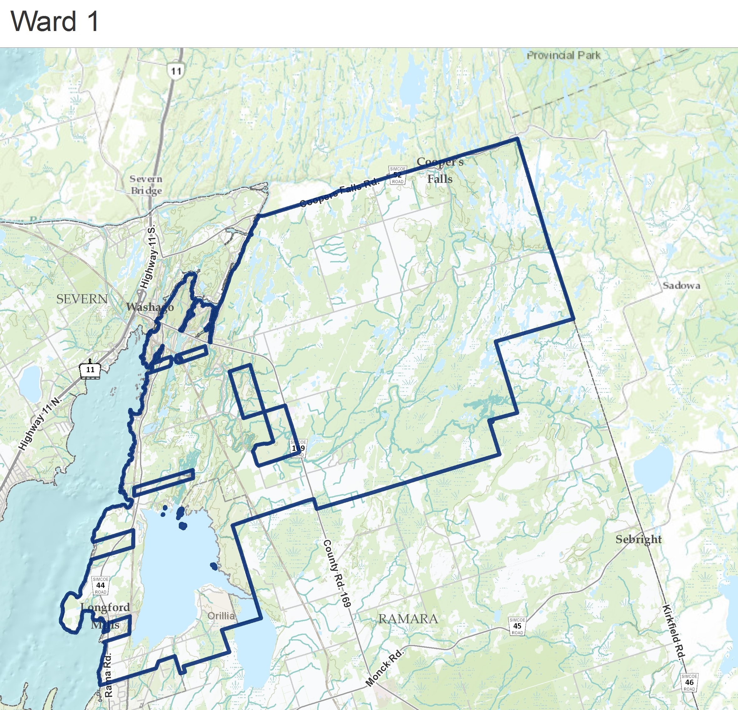
Ward 1 begins at the northern-most point of the Township of Ramara, south of the Black River at Highway 6. The boundary travels the following route:

  • South along Ramara’s eastern border to the southern boundary of Lot 21 Concession I;
  • West along the southern boundary of Concession I to the northwestern corner of Lot 16 Concession H;
  • South along the eastern boundary of Lot 15 to the south-east corner of Lot 15 Concession G;
  • West along Concession G to the northwestern corner of Lot 14 Concession F;
  • South along the eastern boundary of Lot 13 to the southeast corner of Lot 13 Concession F;
  • West along Concession F to County Road 169;
  • North along the midline of County Road 169 to the southern boundary of Lot 15 Concession 5;
  • West along Concession 5 to the northwestern corner of Lot 18 Concession 4;
  • South along the boundary of the Rama First Nations Parcel to its southern boundary;
  • West along and past the southern boundary of the Rama First Nations Parcel to the northwestern corner of Lot 20 Concession 2;
  • South to the southern property line of 3675 Airport Road;
  • West and south along the southern property lines of 3675 and 3785 Airport Road to the eastern boundary of the parcel;
  • North and west along the eastern and northern boundaries of the Rama First Nations Parcel to Lake Couchiching;
  • North and east along Ramara’s border to northern-most point of the Township.

 Map showing the area of Ward 1

Ward 2 where the southern boundary of Ward 1 intersects with the eastern border of the Township of Ramara. The boundary travels the following route:

  • South along Ramara’s eastern border to Lake Dalrymple;
  • Southwest along Lake Dalrymple to Concession Road 7;
  • West along the midline Concession Road 7 to Lake Simcoe;
  • North along the lakeshore to the southern property line of 4166 Glencoe Beach Road;
  • East along the southern property line of 4166 Glencoe Beach Road toward McRae Park Road, and along the midline of McRae Park Road to Sideroad 20;
  • North along the midline of Sideroad 20 to Monck Road (Highway 45);
  • Southwest along the midline of Monck Road to Rama Road (Highway 44);
  • North and west along the midline of Rama Road and the property line of 4358 Fern Resort Road to Lake Couchiching;
  • North along the shoreline to where the shoreline intersects with the southern boundary of Ward 1;
  • East and north along the southern boundary of Ward 1 to the eastern border of the Township.

Map showing the area of Ward 2

Ward 3 begins at the intersection of Monck Road and Sideroad 20. The boundary travels the following route:

  • South along the midline of Sideroad 20 to McRae Park Road;
  • West along the midline of McRae Park Road and the Ward 2 boundary to Lake Simcoe;
  • North along the shoreline to the northern property line of 4358 Fern Resort Road;
  • East along the Ward 2 boundary to Sideroad 20. 

Map showing the area of Ward 3

Ward 4 begins where the southern shore of Lake Dalrymple intersects with the eastern border of the Township of Ramara. The boundary travels the following route:

  • South, west, and north along the Township’s border to where Concession Road A meets Lake Simcoe;
  • Inland, east and north along the boundary of Ward 5 back to the shoreline;
  • North along the shoreline to Concession Road 7;
  • East along the midline of Concession Road 7 to Lake Dalrymple;
  • South and east along the shoreline of Lake Dalrymple to the eastern border of the Township.

Map showing the area of Ward 4

Ward 5 begins at the mouth of the tributary on Lake Simcoe just South of Amilia Road. The boundary travels the following route:

  • North along the river to Concession 6;
  • East along Concession 6, to where it intersects with the eastern property line of 30 Paradise Boulevard;
  • South along the eastern boundary of Lot 13 to Concession 5;
  • East along Concession 5 to the railway; 
  • South along the railway to Ramara Road 47;
  • West and south along the midline of Ramara Road 47 to Concession Road A;
  • West along the midline of Concession Road A to Lake Simcoe;
  • North along the shoreline to the tributary south of Amilia Drive.

Map showing the area of Ward 5

Contact Us

Corporation of the Township of Ramara
2297 Highway 12, PO Box 130, Brechin, ON, L0K 1B0

T. 705-484-5374
E. ramara@ramara.ca


Township of Ramara Legislative Services

T: 705-484-5374 ext. 235
E: clerks@ramara.ca

Sign up for our eNewsletter

Stay up to date on the Township's activities, events, programs and operations by subscribing to have notifications sent directly to your inbox. 

This website uses cookies to enhance usability and provide you with a more personal experience. By using this website, you agree to our use of cookies as explained in our Privacy Policy.